




Checked 19 November 2026. Complete returned UNESCO property text, 2017 Committee decision and National Trust Tarn Hows history read. ICOMOS 2017 evaluation read only through the opening of legal protection; its return ends there. Nomination History and Development PDF read selectively for farming, Great Langdale, aesthetic appreciation, physical changes and early conservation, not as a complete chapter. Ritvo's 2007 paper and bibliography and the complete seven-page Donaldson/Taylor/Gregory report and notes read in original PDF text, not figure images or underlying archives. Eskdale draft 4, dated 13 July 2007, read completely as returned; draft status, uncertain enforcement and governance gaps remain. Related heritage accounts share research. Tarn Hows chronology and planting-intention differences are not resolved here. No original historical plans, period publications, interviews, ecological datasets or present conditions independently inspected.
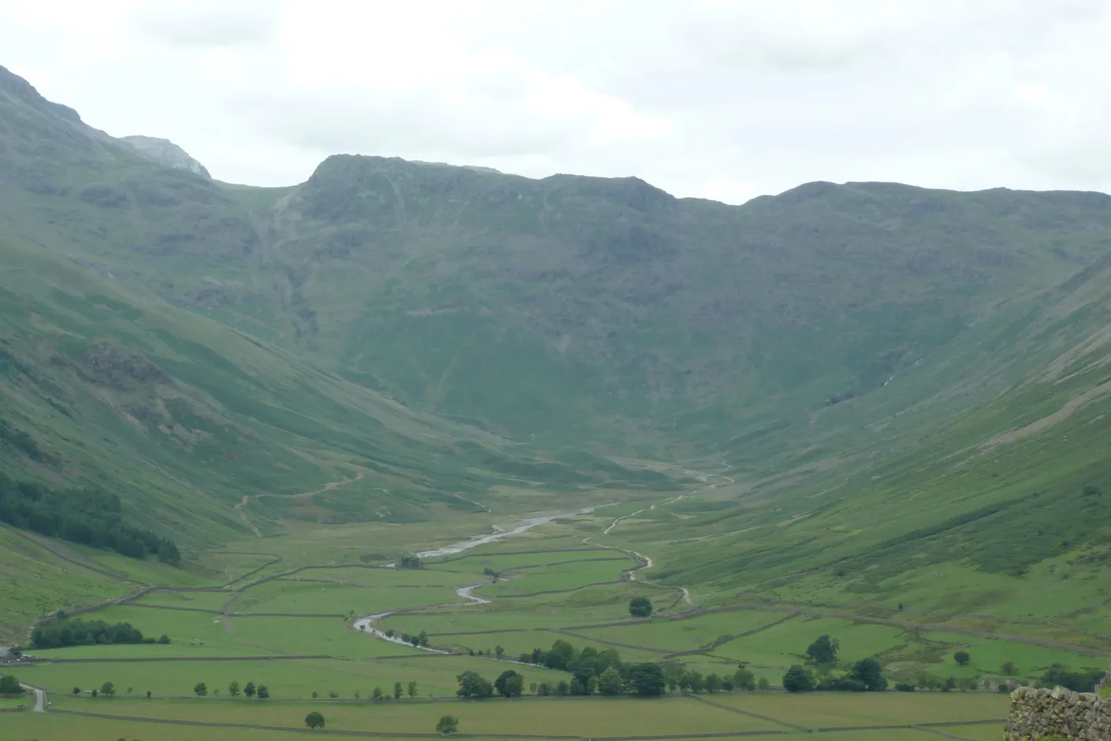
Great Langdale Valley, Lake District, photographed 9 July 2008, not a reconstruction or a present-condition record. Photograph: Paul Stephenson from London, Wikimedia Commons, CC BY 2.0. Recompressed without resizing or cropping. No endorsement implied.

Fields and open fells belonged to a working arrangement
The English Lake District's open slopes were not simply the untouched background to its farms. The World Heritage nomination describes a relationship between enclosed valley land and grazing on the fells above. Farms, fields, boundaries and routes linked different parts of the ground. Their arrangement helped produce the landscape later admired as scenery.
Great Langdale makes that relationship more specific. The nomination's historical case study describes a ring garth, a boundary separating cultivated valley ground from the fellside. It helped keep grazing animals out of crops below. Later intakes, smaller areas enclosed beyond that boundary, extended or formalised the ground attached to particular farms. A wall could therefore mark a change in use and entitlement, not merely decorate a view.
Routes belonged to this arrangement too. The Langdale account describes walled lanes, called outgangs, leading through enclosed ground towards fell grazing. Their widening upper ends helped direct gathered sheep into the lane. Valley fields, enclosing walls and an apparently open slope were connected by the movement of livestock; they were not separate landscape pictures.
The same case study distinguishes reasons for making intakes. Some earlier enclosures increased productive ground; later ones could put walls around lower slopes already used by particular farms for grazing. The new boundary did not necessarily introduce an entirely new activity. It could give an existing use a more fixed physical edge. The valley floor changed too, as land formerly cultivated in common strips was gradually enclosed. The resulting pattern contained different histories within its walls, not one design laid out at a single moment.
That case is not a chronology for every valley. The ICOMOS evaluation identifies variation and the unusually detailed evidence available for Langdale. A historical briefing on Eskdale, Miterdale and Wasdalehead also distinguishes different common-right regimes within one manor. Common grazing did not mean that everyone could use every part on identical terms. The briefing records disputes and uncertainties about enforcement, not a perfectly harmonious system.
The Eskdale briefing supplies another connection between apparently separate areas. Its account of historical grazing regulation links animals on the common with the capacity of the holding to maintain them in winter. Ground producing winter feed and summer grazing above it therefore belonged to a related working geography. The briefing also describes routes to particular grazing areas and lower slopes assigned for milk cows. The open ground was differentiated by movement and use even where a visitor would not find a wall around every part. The briefing's account of the 1587 award distinguishes lower cow pastures, the moor around Burnmoor Tarn for cattle and horses, and higher sheep grazing. Routes took stock from particular holdings towards allotted ground. That distribution matters visually as well as institutionally: a broad stretch of open fell could contain several working areas without displaying the small enclosed-field pattern of the valley below.
Admiration could make human work look natural
Stone walls, tracks, cultivated patches and worked woodland were visible signs of occupation. In her history of the Thirlmere controversy, Harriet Ritvo sets these features beside nineteenth-century descriptions of an unspoilt Lake District. The contrast matters: scenery could be valued as natural even where its admired appearance included long human work. That is Ritvo's historical interpretation, not a description of every observer's beliefs.
Ritvo follows changing responses to Thirlmere's narrow water, steep sides and dark crags. Features that earlier travellers found bleak or threatening became reasons for later admiration. The land did not need to change completely for its significance to change. Descriptions helped select which features counted as beautiful, and those preferences influenced arguments about what should happen there.
Her account of Wordsworth makes the relationship particularly clear. His writing recognised buildings and other human changes while presenting some of them as subordinate to nature. Farmed and inhabited ground could enter the admired scene without appearing to disturb it. A cottage, field or wood was not therefore outside the aesthetic story simply because it served an everyday purpose.
This way of looking did not only encourage people to leave things alone. The nomination also records villas, planted grounds and viewing places added in response to scenic appreciation. A view could become something to compose through changes to the land, not only something to discover. Admiration and intervention were already entangled before later preservation disputes.
Tarn Hows was made into an admired scene
Tarn Hows gives that intervention a physical form. Christopher Donaldson, Joanna Taylor and Ian Gregory's historical report describes an earlier association with a farm and views towards Coniston. The name did not always identify the body of water that later became the scene's centre. The relationship between a named place and its valued outlook changed over time.
Their report and the National Trust's history agree that James Garth Marshall's nineteenth-century work joined three smaller tarns into a larger body of water and included deliberate planting. The resulting scene was not simply an untouched lake waiting to be appreciated. Water, wooded margins and views towards the surrounding hills had been brought into a designed relationship.
The accounts do not agree closely enough to supply one exact project chronology. The academic report places the improvement programme in the 1850s; the Trust describes a purchase in the 1860s followed by the work. Both support nineteenth-century transformation. Choosing one decade without resolving that difference would make the account more precise than its evidence allows.
The planting descriptions also differ. The report emphasises ornamental conifers and sightlines across water and towards the fells. The Trust describes conifers as temporary shelter for young broadleaf trees, left in place after Marshall died. Those explanations cannot simply be merged into one settled original intention. Their common ground is deliberate planting whose later growth changed the appearance of the place.
The report's historical visitor accounts show that the planted trees themselves became part of what people admired. Dark plantations could give the water and distant mountains a valued character. The apparently natural view was therefore not merely farmland with an ornamental addition beside it. Planting changed the composition through which the wider landscape was seen.
Keeping a view meant choosing among changed conditions
Growing trees did not hold the composition still. The academic report describes vegetation changing Tarn Hows's sightlines, then discusses clearing and thinning intended to recover some of them. Removing trees could thus be presented as care for a landscape previously made through planting. Preservation did not necessarily mean leaving every later growth untouched.
The choice was not between a completely artificial scene and an otherwise human-free landscape. The earlier farm and its outlook, the enlarged water, planted margins and subsequent tree growth belonged to different stages. Selecting a view to recover meant giving particular weight to some of those relationships rather than preserving every stage at once.
The report examined a small collection of geotagged visitor photographs to explore which views people recorded. Its authors explicitly described that work as preliminary and hoped to compare later patterns. It does not prove that a completed thinning programme improved everyone's experience. Likewise, the Trust's account of its restoration aims is not an independent measurement of their results.
The useful historical point is the changing arrangement itself. The edge of the water, stands of trees and distant fells could remain recognisable while the views connecting them altered. Looking after that setting required decisions about change within a designed landscape, not the recovery of an unquestionable natural beginning.
Thirlmere made the authority to change scenery a public dispute
Thirlmere brought another kind of proposed transformation. Manchester sought to turn the lake into a reservoir. Ritvo's account follows opposition that drew on the Lake District's scenic and literary value, as well as the interests of affected owners. The controversy concerned a particular water-supply project, but its arguments reached beyond a negotiation over land and compensation.
The proposed alteration would enlarge the water and change its relationship with surrounding ground. Yet the existing setting already contained dwellings, cultivated land, paths, walls and extractive work. Ritvo places these traces beside campaign language presenting the lake as pristine. Opposition to one transformation did not make all earlier transformations disappear.
Woodland makes that earlier work harder to overlook. Ritvo distinguishes trees cleared for agricultural ground from woods supplying local industry, where repeated harvesting could keep woodland in use as a resource. A wooded slope was not necessarily an area left outside the working landscape. Cutting, regrowth and planting could alter the trees beside the water and therefore the appearance of the scene. The presence of trees alone could not establish a single original landscape condition, any more than an open fell could establish an absence of human use.
The Thirlmere Defence Association appealed to people who had no formal property title there. Ritvo interprets the campaign as asserting that attachment to a nationally valued landscape could give people a legitimate interest in its future. That was a claim advanced in public controversy, not proof that its supporters owned the land or had won a general legal right over it.
Property interests and scenic attachment should not be made into sealed opposing camps. Owners took part in resistance, while support also came from farther away. Manchester's advocates argued for the needs of a growing city. The presence of a cherished view did not make those demands imaginary, just as municipal need did not make the landscape empty of inhabitants and existing uses.
The campaign did not stop the reservoir. Ritvo records its completion and the arrival of Thirlmere water in Manchester in 1894. The lake's enlarged outline and altered shores became part of the landscape that later preservation language had to address. This was not an untouched place successfully held outside history.
Protecting the Lake District did not mean freezing one original
Read beside each other, these histories change the meaning of an apparently simple view. A Langdale wall belonged to cultivation and grazing arrangements. Tarn Hows's water and trees belonged to a deliberate scenic transformation. Thirlmere's later lake belonged to a contested municipal project. Similar-looking landscape elements could carry very different histories of work, preference and authority.
Nor should the cases be turned into one project sequence. Tarn Hows did not cause the Thirlmere campaign, and a Langdale field boundary does not explain every later conservation decision. Together they show how the ground people worked, the scene they admired and the conditions they wished to protect could overlap without becoming identical.
UNESCO's formal account celebrates the relationship among farming, aesthetic appreciation and conservation. That heritage judgement does not establish that every resident benefited equally or every landscape condition was ecologically sound. The ICOMOS comparison also qualifies a simple global-origin story: traditions of landscape protection developed differently in different places. The Lake District need not be the sole birthplace of conservation for its disputes to matter.
Our suggestion is to connect the worked ground, deliberate making of scenery and arguments over its future. The question is not only whether a landscape changed, but which changes became admired, which were opposed and who claimed a voice. This is a historical reading of published research, not a present-day assessment of access rights, water infrastructure, conservation results or conditions on the ground.
Sources
- S1: UNESCO, property account and 2017 Committee decision framing
- S2: Nomination History and Development, selected farming, Langdale, aesthetic and conservation passages
- S3: ICOMOS 2017 evaluation, bounded return and comparative qualifications
- S4: Harriet Ritvo, 2007, complete historical paper, Thirlmere controversy
- S5: Donaldson, Taylor and Gregory, complete Tarn Hows report and notes, preliminary visitor-photo study
- S6: National Trust, Tarn Hows history, estate-manager account
- S7: Eskdale historical briefing, draft 4, 13 July 2007, local rights and governance
Questions people ask at the gate
Were the open fells simply untouched countryside?
No. The historical accounts connect valley cultivation, common grazing, boundaries and routes. Arrangements differed by valley. Common land does not mean identical entitlements for everyone or establish a present right of access.
What does a Langdale wall explain beyond the view?
The ring garth separated cultivated valley ground from grazing above. Later intakes enclosed additional areas, and walled lanes connected farms with the fells. Those relationships concern land use and movement, not one date or function for every wall.
Was Tarn Hows an unchanged natural lake?
No. The academic report and Trust history describe joining smaller tarns and deliberate planting. They differ over exact timing and planting purpose. The supported shared account is nineteenth-century transformation followed by changing vegetation and views.
Does restoring a sightline prove a conservation success?
No. The report discusses intended work and a preliminary visitor-photo study, not a completed evaluation showing universal benefit. Historical landscape interpretation is different from measuring ecological outcomes or today's management results.
Did people opposing Thirlmere all own land there, and did they win?
No. Ritvo describes both property interests and a wider appeal to people without formal title. The campaign failed to stop the reservoir. Those public claims are not a present legal right or proof of ownership.
Was the Lake District the sole birthplace of landscape conservation?
No such claim is made. ICOMOS qualifies the international comparison. The historical importance here is the relationship between working ground, scenic appreciation, material intervention and competing claims over change, not a universal origin story.
Next walk starts at a new gate.
Was this helpful?
one tap, no sign-up

A Miranda House graduate and lawyer who traded courtrooms for slow travel. Cheshta travels with the batches we host ourselves, with a soft spot for travelling alongside elders.