

Checked 19 November 2026. UNESCO complete returned English account; Herrmann 1997 foundation article and notes; Herrmann AI 1997/98 complete pp 32-36 and notes; Williams 2008 all 69 numbered main-text pages, 16 appendix pages, bibliography and acknowledgements; Williams 2012 complete pp 54-68, notes and references; Simpson 2001 complete returned pp 14-15 and bibliography read. These are six publications, not six independent confirmations. Authors and project research overlap. Selected publication pixels inspected, not all figures, GIS, underlying field archives, audio/video or datasets. Simpson original PDF download failed, no original page-pixel claim. Preliminary dates, proposed boundaries, cultivation and building functions remain qualified. No interior, ritual, military or hydraulic performance, migration cause, current condition, route, access, title or safety claim.
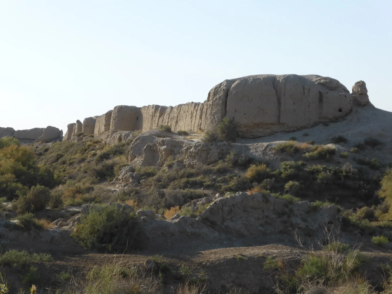
Merv city walls. Photograph: Hans Birger Nilsen, 11 October 2018, via Wikimedia Commons, CC BY-SA 2.0. Recompressed without resizing or cropping; this image version remains under CC BY-SA 2.0. General illustration, not identification of a particular enclosure or a present-condition record. No endorsement implied.

A change of centre did not empty the older enclosure
Merv's ancient enclosures stand beside one another rather than forming a single outline. Herrmann's published plan places the small Erk Kala at the northern side of the much larger Gyaur Kala, with Sultan Kala to the west. The later Abdullah Khan Kala lies separately to the south.
Erk Kala became the citadel of the larger settlement around it. Later, the principal urban focus developed west of Gyaur Kala, in the area called Sultan Kala. Herrmann describes much of Gyaur Kala turning to industrial use, while Simpson identifies workshops within its formerly inhabited ground.
The new centre also developed from ground outside an earlier city. Herrmann describes Sultan Kala beginning as an extramural suburb before receiving its own enclosure. What had been outside one urban wall became the principal built area of another phase. The relationship between centre and enclosure therefore changed twice: activity spread beyond an older perimeter, and a later perimeter bounded the newer town.
Herrmann describes Gyaur Kala as a broadly regular enclosure, while Sultan Kala's less regular perimeter reflects its different growth. The northern and southern extensions add further enclosed ground to the medieval town.
Tracks and open intervals organised the older city's workshops
Simpson reports that surface survey and observation of its small changes in ground level suggested separate workshops, some clustered near tracks running between the east and west gates. Other clusters related to a line from the centre towards the southern gate. Buildings were therefore distributed in relation to connections across the older enclosure, rather than forming one continuous industrial block. Other workshops were separated by large open spaces.
Simpson places the furnaces in open ground at the rear of a mudbrick workshop, whose rooms were arranged around a paved courtyard.
That particular workshop cannot stand for every group identified across Gyaur Kala. The wider distribution comes from survey, whereas the courtyard arrangement comes from excavation of one complex.
Dense streets belonged to only part of the newer city
Williams describes a densely built core on both sides of the north-south Madjan Canal in Sultan Kala. Streets and alleys separated building plots, while houses and larger complexes occupied adjoining ground. His aerial image of one quarter shows tightly interlocking remains and small open depressions beside the central line.
The street system was roughly regular without repeating a perfect grid. Some streets extended across a substantial part of the town; others were shorter and changed alignment slightly. Many ended in T-junctions or staggered crossroads. Those interrupted connections divided the built ground into differently shaped blocks rather than carrying every line uninterrupted from one side of the enclosure to the other.
Smaller alleys differed from the longer east-west streets and from the canal's north-south line. The larger lines connected districts, while the smaller divisions separated and reached more local building groups.
The same source distinguishes substantial courtyard complexes among the denser buildings. Their open centres interrupted the closely packed fabric at another scale, different from either a street or a broad unbuilt area. Williams notes possible groupings of larger courts along major streets, but does not establish a secure function for each complex.
Later walls enclosed structured open ground as well as buildings
Williams contrasts crowded quarters with substantial open areas towards Sultan Kala's eastern and western sides. In the south-east, buildings extended back from a major east-west street while larger unbuilt areas lay beyond them.
Some open spaces were rectilinear and bounded by substantial building complexes; Williams considers many of these likely courtyards. Other, less regular spaces occupied larger areas within the later walls. Their edges followed neighbouring buildings, and lines visible within them suggested further divisions.
Williams proposes that an angled break through the western street pattern might mark an earlier urban boundary. In that interpretation, later walls enclosed ground that had previously lain outside the town's built core. The proposal connects different street alignments, enclosure and building density, but it is not an excavated boundary securely dated along its whole length.
Gardens, orchards and fields are possible interpretations of some of the structured open ground, not verified identities for every patch.
Buildings outside the later perimeter still related to the town
West of Sultan Kala's later walls, the published imagery identifies substantial complexes near the road leaving the western gate. Williams describes one possible caravanserai as two adjoining courtyard enclosures, with another, less clearly preserved example to its south. Their position beside a principal connection differed from the tightly packed housing of the urban core. The building identifications depend partly on form and location.
Farther south, the Greater and Lesser Kyz Kala stood within the town's immediate surroundings. Other building traces and enclosures lay between the prominent standing monuments. Modern cultivation has damaged some of those intervening traces.
Williams describes the Greater Kyz Kala as a nearly square building with a sloping lower base and tall corrugated upper walls. A ramp approached its eastern side. That substantial compact mass differed from the nearby double-courtyard enclosures, even though both belonged to the broader ground west of the city.
Williams argues that the later western circuit stood farther out than a proposed earlier boundary, bringing the urban edge closer to previously external complexes. His discussion also suggests changed connections where an earlier crossing was not obviously repeated in the later wall. These remain interpretations of the evidence, not proof of a precise historical itinerary or unrestricted passage.
Possible gardens, pasture and cultivated spaces formed part of his reconstruction of these surroundings. But he explicitly allows alternatives: later activity might have encroached on earlier elite grounds, or different elements might have continued together. The suburban buildings and open areas cannot all be assigned confidently to one moment.
Later occupation prevents one universal ending
The sources disagree about reoccupation. UNESCO's integrity account says the abandoned sites were never occupied again. Herrmann's preliminary project accounts instead report post-Seljuk and post-Mongol activity, including later phases in a limited citadel excavation. Neither a broad heritage statement nor one excavation supplies a complete occupation history for every part of Merv.
Williams offers a further bounded account: much of Sultan Kala's visible landscape may reflect the late twelfth and early thirteenth centuries, while some areas were abandoned earlier and some buildings reused afterwards. This does not automatically reconcile UNESCO and Herrmann.
Sources
- S1: UNESCO, Ancient Merv
- S2: Herrmann1997, The Medieval City of Merv
- S3: Herrmann, Archaeology International1997/98, pp32-36
- S4: Williams2008, The landscapes of Islamic Merv
- S5: Williams2012, UAV Photography, pp54-68
- S6: Simpson2001, IAMS21, pp14-15
- Hans Birger Nilsen, original Merv city walls photograph
- Photograph and image version: CC BY-SA 2.0
Questions people ask at the gate
Did a westward shift leave Gyaur Kala completely empty?
That is not the published account. Herrmann and Simpson describe industrial activity within the older enclosure, with workshops related to tracks and separated in places by large open spaces. This does not establish continuous occupation of every part.
Was Sultan Kala filled evenly with buildings?
No. Williams distinguishes dense quarters, larger courtyard complexes and substantial structured open areas. Possible cultivation is an interpretation of some open ground, not a certain function for every space within the walls.
Was the street system a perfect grid?
Williams describes roughly regular streets with shorter deviations, T-junctions and staggered crossings. Smaller alleys formed another scale of division. That account does not reconstruct every connection or provide a visitor route.
Were the external complexes certainly all caravanserais?
No. The identifications rely partly on shape, scale and location. Some complexes are less clear, and their chronology is tentative. The evidence supports substantial activity outside the later walls without settling every building's function.
Do the sources agree that Merv was never reoccupied?
No. UNESCO's integrity wording differs from Herrmann's preliminary reports of later occupation. Williams also allows some later reuse within a largely earlier urban landscape. The disagreement is not silently resolved here.
Does the overall plan show every part operating at once?
No. Centre, enclosing wall and occupied ground changed differently. The earlier boundary and suburban reconstruction contain hypotheses, and local later occupation does not prove uninterrupted citywide continuity. No present condition or access is established.
Next walk starts at a new gate.
Was this helpful?
one tap, no sign-up
A Miranda House graduate and lawyer who traded courtrooms for slow travel. Cheshta travels with the batches we host ourselves, with a soft spot for travelling alongside elders.